I'm announcing FOTBCD, a national-scale building change detection dataset derived from authoritative French orthophotos and topographic data, designed for robust geographic generalization and commercial use.
FOTBCD is a large-scale building change detection dataset derived from IGN (Institut national de l'information géographique et forestière) 's authoritative aerial orthophotos and topographic building footprints. It covers 28 departments across mainland France at 0.2 m resolution, with a strict geographic train/test split (25/3 departments) to evaluate genuine spatial generalization across diverse urban, suburban, rural, coastal, and mountainous environments.
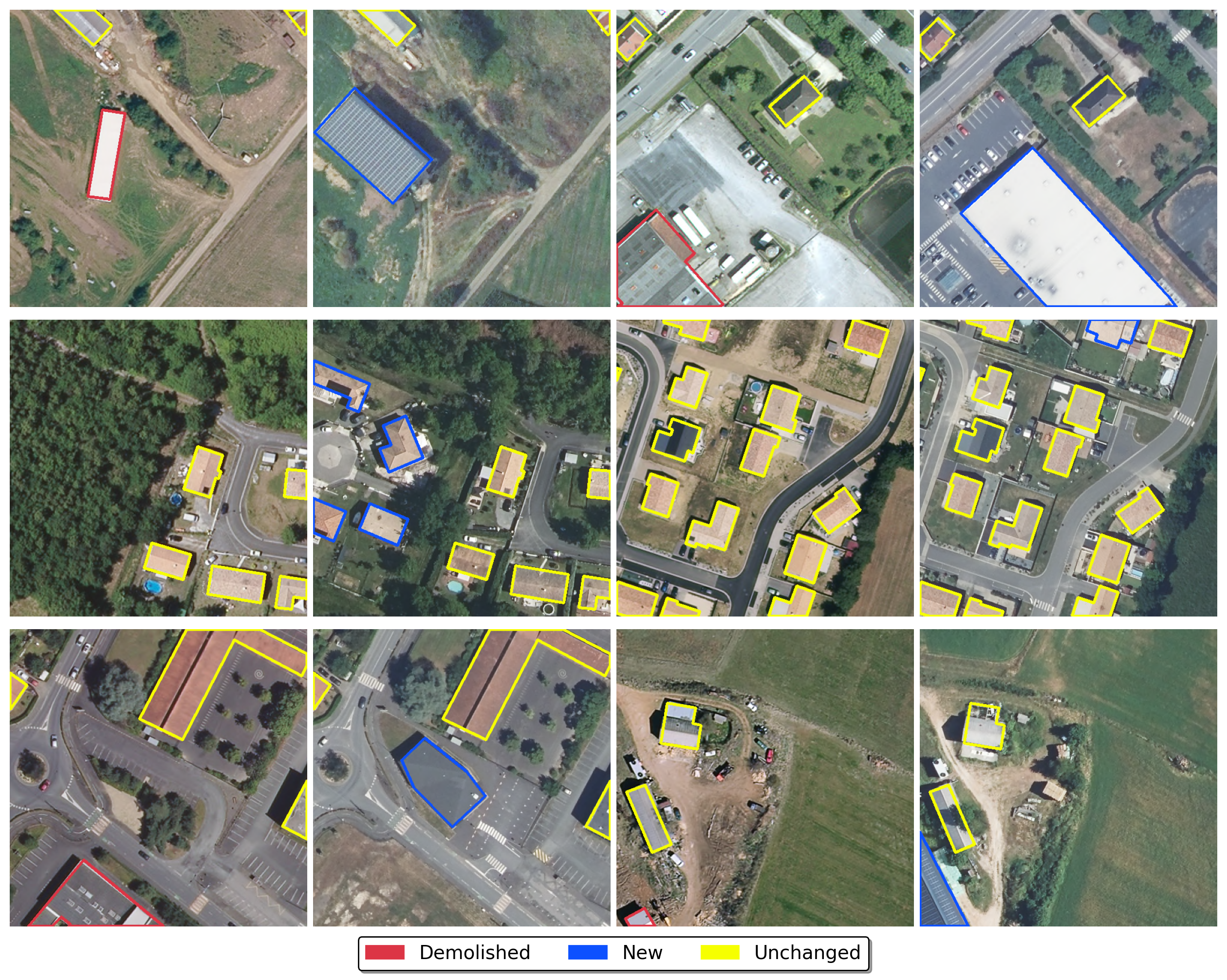
Unlike most benchmarks that reduce change detection to a binary segmentation task, FOTBCD supports directional labeling: buildings are classified as newly built, demolished, or unchanged — enabling models to distinguish construction from demolition. Two derived community datasets are publicly available:
- FOTBCD-Binary — binary no-change/change masks derived from newly built and demolished building polygons, optimized for large-scale training and benchmarking
- FOTBCD-Instances — a sample from FOTBCD with instance-level polygon annotations
Cross-dataset experiments confirm that geographic diversity is a first-order factor: models trained on FOTBCD transfer substantially better to other benchmarks than models trained on geographically narrow datasets.
All data derives from IGN's open data program, providing a legally clear foundation for both research and commercial use. The integral dataset, FOTBCD (223k+ image pairs, 960k+ building polygons), is available under a dedicated commercial license — contact me for licensing.
- Paper: https://arxiv.org/abs/2601.22596
- GitHub (datasets, training code, checkpoints): https://github.com/abdelpy/FOTBCD-datasets
Citation
@misc{moubane2026fotbcd,
      title={FOTBCD: A Large-Scale Building Change Detection Benchmark from French Orthophotos and Topographic Data},
      author={Abdelrrahman Moubane},
      year={2026},
      eprint={2601.22596},
      archivePrefix={arXiv},
      primaryClass={cs.CV},
      url={https://arxiv.org/abs/2601.22596},
}
Data sourced from IGN's BD ORTHO and BD TOPO under Licence Ouverte / Open Licence v2.0.